
Atlas of Urban Expansion
Angel Shlomo, Jason Parent, Daniel L. Civco, and Alejandro M. Blei
Cambridge, 2012 | ISBN 9781558442436
The Atlas of Urban Expansion is a comprehensive guide to the past and future characteristics of metropolitan growth. In 2010 more than half of the world’s total population lived in cities, and this share is expected to increase to 70 percent or more by 2050. The world’s urban population is expected to increase from 3.5 billion in 2010 to 6.2 billion in 2050, and almost all of this growth is expected to take place in less-developed countries. Cities in developed countries will add only 160 million people to their populations during this period, while Cities in developing countries will need to absorb 15 times that number, or close to 2.6 billion people, thereby doubling their total urban population of 2.6 billion in 2010. Given the expected decline in urban densities, these cities are likely to more than triple their developed land areas by 2050.
The main objective of this Atlas of Urban Expansion is to increase understanding and help residents, policy makers, and researchers around the world come to terms with the expected global urban expansion in the coming decades. The call to action is urgent, as the urbanization process now underway will be largely completed by the end of the 21st century. “Most people who desire to live in urban areas will already be in them by 2100, but by that time it will be too late to act,” Angel says. “If the land required for public works or public open spaces is not protected from encroachment before it is developed, it will be next to impossible to ensure the orderly development of cities to make them more efficient, more equitable, and more sustainable.”
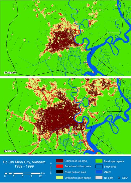
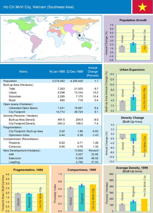
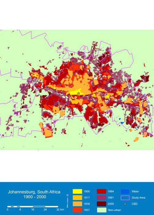
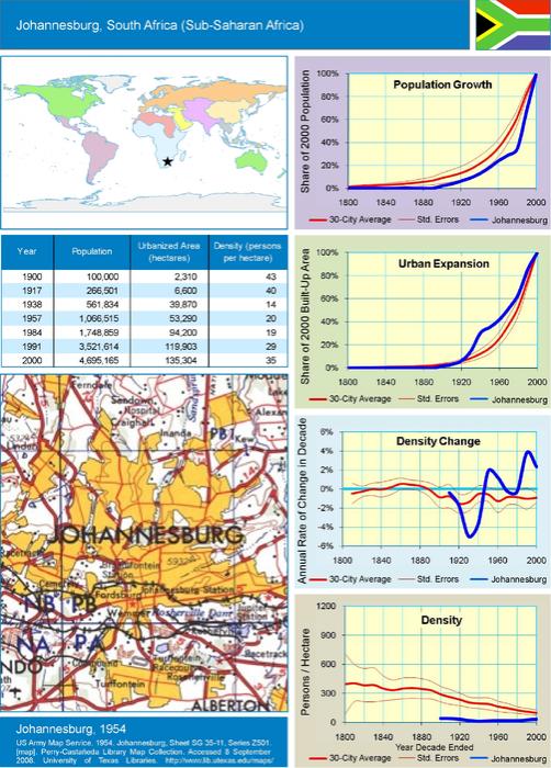
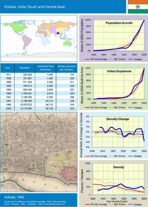
The Atlas in book form introduces the project and presents two sets of full-color maps and a set of raw data tables. The first map section contains pairs of urban land cover maps from circa 1990 and 2000, representing a global sample of 120 cities. The second map section includes composite maps of a global representative sample of 30 cities, showing the historical expansion of their urbanized areas from 1800 to 2000. In both sections, the maps shown are paired with numerical and graphical data, making it possible to compare cities in terms of their metric values on key attributes of urban expansion. The third section contains four extensive tables of urban, national, and regional data for each of the 120 cities.
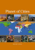
The companion volume, Planet of Cities, also authored by Lincoln Institute visiting fellow Shlomo Angel, lays out a series of recommendations for making adequate room for increased urban population growth, rather than emphasizing containment; adjusting densities within a sustainable range; providing an ample supply of urban land for decent housing; and securing land necessary for public streets, public infrastructure networks, and public open spaces well in advance of development.
CONTENTS
• List of Illustrations
CHAPTER 1
The Dynamics of Global Urban Expansion
CHAPTER 2
Understanding and Measuring Urban Expansion
CHAPTER 3
The Global Sample of 120 Cities, 1990 - 2000
CHAPTER 4
Historical Perspectives on 30 Cities, 1800 - 2000
CHAPTER 5
Urban, National, and Regional Data
• Acknowledgments
• References
• Historical Map References
• About the Authors
• About the Lincoln Institute of Land Policy
ABOUT THE AUTHOR:
Shlomo Angel teaches the History and Theory of Planning at the Wagner School in New York. He also teaches a similar course at the Woodrow Wilson School of Public and International Affairs at Princeton University, New Jersey. He is currently the principal investigator in a global study of urban expansion that has been financed by the World Bank, the National Science Foundation, NASA, and lately the Lincoln Institute of Land Policy.
ABOUT LINCOLN INSTITUTE OF LAND POLICY:
The Lincoln Institute of Land Policy is a leading resource for key issues concerning the use, regulation, and taxation of land. Providing high-quality education and research, the Institute strives to improve public dialogue and decisions about land policy. As a private operating foundation whose origins date to 1946, the Institute seeks to inform decision making through education, research, policy evaluation, demonstration projects, and the dissemination of information, policy analysis, and data through our publications, Web site, and other media. By bringing together scholars, practitioners, public officials, policy makers, journalists, and involved citizens, the Lincoln Institute integrates theory and practice and provides a nonpartisan forum for multidisciplinary perspectives on public policy concerning land, both in the U.S. and internationally.


Planum
The Journal of Urbanism
ISSN 1723-0993
owned by
Istituto Nazionale di Urbanistica
published by
Planum Association