
Street Life: Porto (Portugal)
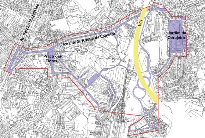
'Plano Urbano da Avenida Fernão de Magalhães / V.C.I. - I.P.1 / Praça das Flores': A contemporary Public Space
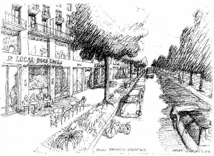
Patrício Martins
The Project / Plan
Year: 1995 - now
Site: Campanhã district, Porto city, Portugal
Team: Architecture - Jorge Patrício Martins (coordinator), Ilídio Ramos
Geography - António Pedrosa, Fantina Pedrosa,
Anthropology - Fernando Matos Rodrigues
Sociology - Pedro Pombo
Infrastructure - António Castro Melo
Landscape Architecture - Manuel Ferreira
Other collaboration - GPU, Geoconsult
Client: Porto City Hall
Status: under construction
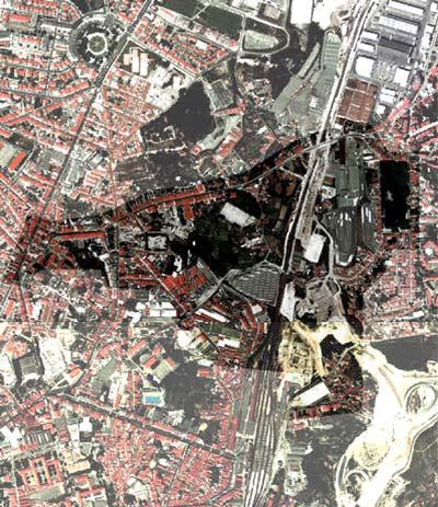
The city district
Located on the edge of Porto, the Campanhã district has been dissected since the 19th century by the railway. It has an irregular morphology that renders accessibility difficult, inert industries, dilapidated social housing and an aged, unemployed and low-income population living in a marginal location with low standard and a complete lack of services and public spaces. Taken all together this creates a stigma in the population, excluded from urban uses and benefits.
Geographical, economic and social context
The plan area belongs to a territory located between the consolidated city and the suburbia of Porto, next to the Bonfim district and reasonably central in the Campanhã district, covering an area of around 75ha. Campanhã is the largest and most populous of the city's districts, with nearly 50.000 inhabitants.
'S. Roque da Lameira St.' still functions as a radial road, which has structured this part of the city for a few centuries and connects to Gondomar, Valongo and Penafiel, through the heavy commuting of their inhabitants. This arterial road's high level of pollution is one of the problems to be solved.
This region is characterized by rural qualities lending it a special interest (there are still many green open spaceswith high landscape value), rather old and decaying residential neighbourhoods, as well as decaying industrial activities facing permanent difficulties and a lack of infrastructure and community services.
The local population faces not only low incomes, but also unemployment, disillusionment with the social conditions in which they find themselves allied to drug use, crime, alcoholism, prostitution and marginal activities in general that affect the area resulting in a clear urban deficit and a poor image.
To the barrier effect caused by the railway when it was first built at the end of the 19th century, were recently added the VCI/IP1 (inner city belt) and the subway under construction. However, it is with this large-scale infrastructure that this district may acquire some visibility, not only local but also regional.
Streetlife: new designs for Public Spaces
The contemporary public space should respond to the expectations and needs of emerging social groups. In this respect we encounter a depressed situation, which during the last decade has had as an outcome the loss of the most active part of population to neighbouring areas. To counteract this tendency, resolutions were taken in order to promote attractiveness, especially by encouraging real estate and aiming at various social sectors and by improving environmental conditions. It is also a special aim to invest and draw in supporting services and revitalize the commercial activity inside the proposed residential core.
In the area plan public space occupies only 19%, being almost restrained limited to a narrow space of overcrowded streets. On the other hand, the existing services are as precarious as their quantity, quality and diversity.
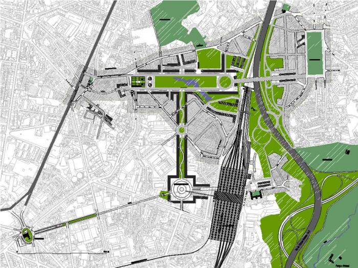
The proposed Avenue's central corridor will become the backbone of this eastern sector;, an alternative and multifunctional focus with a range of services it will emphasize this new centrality, abandoning its previous industrial decay by implementing infrastructure which may stimulate progressive replacement by more flexible and modern activities. Along with this, in the general picture there is also a search for a functional balance within the city itself.
The services will be both administrative and civic as local support to sport, schools and leisure. In the meeting spaces, the intervention achieves a layer of pavement design and street furniture, where the question of identity and the feelings of belonging are preserved by the creation of singular marks in drawing symbolic spaces. Concerning the buildings and complementary to the existing structures, the plan proposes a scenario of architectural quality.
Regarding the superficial infrastructure, the relationship with the former street structure is accomplished by means of transverse connections, not only to the most developed areas of this sector but also to the city centre. At a metropolitan scale, it should be able to reconciliate the converging flows, whether transit, arrival and destination, achieving an eventual significance as a distributing platform.
Objectives of the project / plan
In the present context of the Metropolitan Area of Porto, a new thrust in the 'idea of the city' should be implemented. According to the city's planning strategies, several working objectives/themes were established:
1. - to develop the culture of a new centrality capable of placing Campanhã on the city map, contributing to developing and articulating this eastern sector to the main central areas of the metropolis.
2. - to redesign the public space in a system of green paths, environmental care and urban landscape, enhancing a better relationship between the city's 'Acropolis' and Douro river.
- the 'green path' should preferably establish pedestrian links between the various collective, public and private amenities, existing or to be built, even those at higher levels.
- to diversify the use of public space investing in the leisure and cultural activities associated with the new amenities and image.
- to systematize the car circulation and parking.
3. - to improve the accessibility and the mobility of the articulation and connection of the networks of the different public / private transport modes - considering the 'Interface' next to Campanhã's railway station also planned to be an essential aspect of the urban evolution of this sector.
4. - to increase the diversity of uses of the built environment, giving priority to housing though allowing commercial uses and other services.
- to maintain some non-polluting industries as well as commercial / service activities that will generate jobs and attract population needed for the urban dynamic.
5. - to establish a methodology of systematic coordination among the different agents interested in the transformation of this territory, creating conditions for balanced urban forces.
- to define territorial units that reveal typological and morphological homogeneity aiming to simplify the aforementioned urban forces.
6. - to alter the limits of the area / plan in a way that assures a better relationship of the proposal to the adjoining region, so that the interrelationship of the existing fabric may be realised.
Strategy and results of the project
The problem of this plan is the reconciliation of the new inner city highways and their relationship with the urban fabric. These highways cross the city, adversely affecting the area by dividing it; they are justified by the need to solve accessibility problems that might revitalize the inner city and arrest its decay. Taking this into consideration, the V.C.I. was built over the railroad also solving the problem of expropriation and the expansion of 'no man's land', built as a viaduct allowing the interlinking of the urban fabric.
On the other hand, the theme of intervention on the city's fringes, with obsolete industries, is an opportunity to create urban fabric in remaining open spaces, that are at present empty or are experiencing low levels of construction. It creates higher densities and introduces a new language, granting livability to the smallest public space, making it easier to invest in housing and employment, which will bring in new people to integrate with the local population. The existing green areas are linked by footpaths from the higher part of the city to the river. Significance is given to the human scale.
Detailed studies
At the same time as the preliminary studies were started the detailed projects of the plan were begun, including the following, where the public space intervention is crucial:
• Interface Area
Projected on a large roundabout with inner installation for the interface (the future subway will serve this area) and direct access to underground parking. In this way, four squares are created between the roundabout and the sides of the outer square where the buildings are placed. It connects with the main avenue through a curved street functioning as a green corridor containing a series of meeting places.
• Joaquim Urbano Hospital area
The entrance from 'Fernão Magalhães Avenue' as a tunnel caused the partition of a local street. In order to re-establish the footpath, a connection was made as an elliptical ramp emphasizing the concept of gateway. A new design for the churchyard of the existing chapel is also proposed, and also for the steps and ramp that access it.
• 'Praça das Flores'
Due to the planned avenue, a redesign of the present square is proposed, adapting it to the new scale of the area and allowing for underground parking.
• 'Avenida 25 de Abril'
A leisure park is created between the new streets with continuous construction on both sides, concluding both ends in a evocation porticos, one of which separating the avenue from 'Praça das Flores' and the other one accessing the viaduct over the V.C.I. and railroad and connecting to 'Praça da Corujeira'. From this last one, two parallel descending routes part heading to the highway intersection. The viaduct will be partially surrounded by buildings reducing the crossing open area and achieving characteristics of urban street, continuing the urban tissue of 'Praça da Corujeira' towards the Western sector.


Related articles:
- Street Life: Cosenza (Italy)
- Street Life: Dublin (Irland)
- Street Life: Graz (Austria)
- Street Life: Groningen (The Netherlands)
- Street Life: Leeds (United Kingdom)
- Street Life: Munich (Germany)
- Street Life: Nijmegen (The Netherlands)
- Street Life: Regensburg (Germany)
- Street Life: Salerno (Italy)
- Street Life: Strasbourg (France)
- Street Life: Turin (Italy)
- Street Life: Vienna (Austria)


Planum
The Journal of Urbanism
ISSN 1723-0993
owned by
Istituto Nazionale di Urbanistica
published by
Planum Association