Genova: River basin management plans and integrated urban and territorial planning: common language, eco-technical rules and environment projects for fluvial parks and watercourse systems
Physical domain and characteristics
The territory of the Province of Genoa (t.s. 1854 Kms; inhab. 920.549, more than half of the whole Liguria region) is characterised by four tributaries of the river Po on the internal slope, and by twenty six torrential river basins and a multitude of running water areas on the Tyrrenic slope.
Morphology is of the Apennine type with rapid and short slopes.
Intense weather phenomena with sheet of rain centres, even on small portions of river basin, brought about a number of diversified and concentrated hydro-geological instabilities.
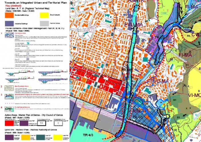
The case under consideration, as on side figure, is a strongly urbanised part of the Chiaravagna small river basin (11 Km), that in the course of time suffered wide-ranging urban degradation and environmental instability, as a consequence of incorrect and sometimes careless decisions.
Type of planning instrument
The process of river basin planning of the Province of Genoa, as a transferred authority, is regulated by Regional Laws n°9/93 and n°18/99 on land defence and n° 36/37 on urban and territorial planning, it was elaborated in connection with regional programming and planning functions.
Innovative contents
The river basin plans are being considered as:
- tools for the integration between the hydro-geological and hydro-graphic network re-settlement, the preservation of quality of water bodies; tools for the rational use of water resources and ecological re-qualification of land use and coastal defence and re-evaluation
- structural and strategic plans for their prescriptive prevalence over the local, provincial and regional planning, for the multiplicity of investigated fields, for the environmental value and the global method to take decisions on the territorial system level, for their significant fall-out on the urban policies, and for their capacity to co-ordinate and integrate the local planning with other planning levels;
- technical operational tools to define the policies for the organic management of the hydro-graphic basin as a whole, to integrate the anthropic and natural phenomena with the urban and territorial re-qualification processes, to cross the specialistic boundaries by a global policy of environment and territorial management in conformity to sustainable choices.
- tools for the hydraulic and hydro-geological risk mitigation concerning the riverbeds and slopes in connection with the resettlement and environmental re-qualification of the urban and naturalistic areas that concern river course landscapes;
- instruments of knowledge (founding description) having the capacity to take in multidisciplinary way the complexity of problems about land and underground use. These instruments point out, by using integrated synthesis maps, the susceptibility to instability, the components of risk, the location of risk level and their effects over the settlements, as well as the individuation of co-ordinated interventions, structural works and non structural, as regulations, obligations, prescriptions, eco-technical rules and environmental indicators;
- tools of location to set the main territorial instabilities such as the hydraulic insufficiency in the terminal part of watercourses with the aggravation of the presence of a urban sprawl; the short water running time; the situation of the instability conditions and diffuse erosion slopes, the absence, or biological inefficiency, of plant cover; the Italy's most frequent and intense flood events.
The method
The used analytical foundations are: information survey of physical structure , of land and underground use; information cadastral maps of present hydraulic structures of their environmental contexts, as well as of the landslides and of the mining industry. Use of technologies G.I.S. and of by it them derived maps of land use synthesis so as, to confront and to integrate with the maps of urban and territorial planning.
It is inserted at territorial level the preventive evaluation, of the whole of the intervention which are to realise in terms of social costs, of environmental sustainability and of available financial resources. For to activate that it is used the method of to make a comparison between alternative solutions as possible applications of the process of "Strategic Environmental Impact Assessment" (E.I.A.).
Have been activated consultations with Mountain Communities, Local Authorities, Associations and Citizens. It is predictable that in the near future, electronic media will be more widespread, making it possible to reach some level of co-planning and public participation to the decision-making process.
Towards an Integrated Urban and Territorial Plan
The new pattern of planning is based on the urban and territorial co-ordination and integration of river basin management plans in a reciprocally nested way, both on the local and wide area level. This plan is structural strategic, cognitive and operational and is based on the fact that the drafting on this particular tool is to realise through the following means:
- the structuring of a common language of planning unifying and re-organising the multitude of authorities, decision-making levels, symbols and planning tools;
- the wording of a unified model of graphic legend whose elements are items of G.I.S.
It is articulated at the level of "founding description" an of integrated urban and territorial design;
- the definition of strategies and methods of knowledge and planning integration;
- the multidisciplinary identification of fluvial parks or watercourse system environmental projects that are meant as instruments for the resetting of the watercourse landscape, the environmental re-qualification and the town and land redevelopment;
- the definition of eco-technical rules for the sustainability.
In conclusion it is necessary to make on the network the whole of the urban and land planning tools and aims, items and procedures.
Workteam
Paolo Tizzoni: vice-president and land defence delegate
Mauro Lombardi: director of area 06 land defence, environmental works and river basin plans
Aurelio Giuffré: office manager for river basin plans
Clara Sterlick: office for river basin plans
Giovanni Spalla: scientific consultant
Paolo Repetto: collaborator
Referent: Arch. Clara Sterlick
Related articles:
- 4th National Urban Planning Exhibition
- Firenze: Guide plan for the formulation of the landscape programmes provided for the 'Piano Territoriale di Coordinamento' of the Province of Florence
- Grosseto: Territorial Plan of Coordination
- Grugliasco: the Town Development Plan
- Reggio Emilia: the 1999 Town Development Plan
- Venezia: Three Projects for the Heart of the Town - Piazza Ferretto - Torre dell'orologio - via Palazzo


Planum
The Journal of Urbanism
ISSN 1723-0993
owned by
Istituto Nazionale di Urbanistica
published by
Planum Association