Cultural Heritage: Apeldoorn (The Netherlands)
Canal Zone (Kanaalzone)
Jeroen Baeten
Basic information
Apeldoorn: 153.000 residents
Surface area: Municipality 34100 ha
Urban area 5300 ha
Planning area 225 ha
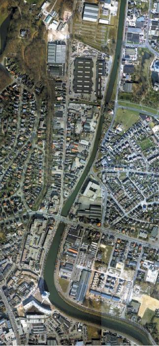
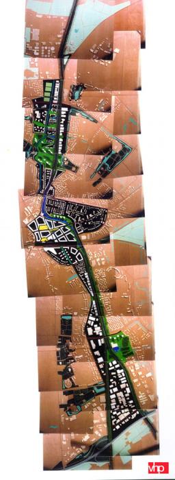
The outline plan addresses the redevelopment of Apeldoorn's urban canal zone. The canal zone (Kanaalzone) is an elongated industrial area which transects the city's urban area in a north-south direction. The plan was drawn up by the 'VHP stedebouwkundigen, architecten, landschapsarchitecten' consultancy on the request of and in close collaboration with the municipality of Apeldoorn. The outline plan, which was adopted in 2001, constitutes the basis for the elaboration of the various sub-plans. It will be implemented in phases during the long-term (30 years) redevelopment of the zone.
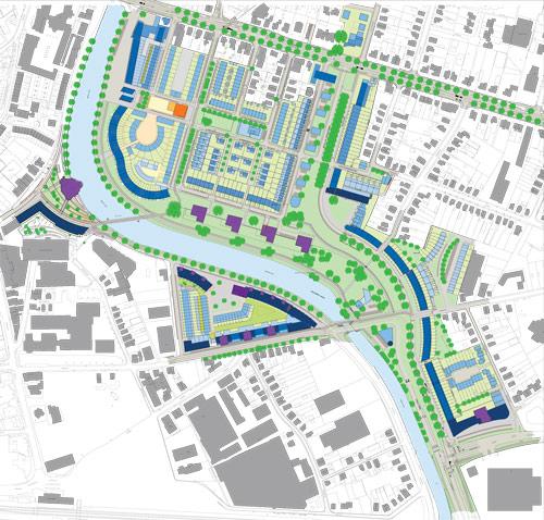
The Rein Geurtsen en Partners consultancy developed a Master Plan (1993) for the Canal Bank project, concerning the redevelopment of the central part of the area, together with a number of townplanning designs detailing elements of the Master Plan. The Atelier Quadrat consultancy drew up the designs for the public spaces. These plans have since been implemented, or are due for implementation within the near future. They can be seen as a model for future developments within the Kanaalzone.
Context
The Kanaalzone is located in the heart of Apeldoorn's urban area. The region's industry - originally related to the canal - is largely outdated, and the area now has a dilapidated appearance. The canal has played virtually no role in Apeldoorn's post-war development; the new Zevenhuizen and De Maten neighbourhoods 'ignore' the canal, and the presence of industry in the ribbon along the canal forms an inconvenient obstacle between the city's eastern and western districts. The nature of the zone's industry and its concomitant environmental problems render the region increasingly incompatible with the urban (residential) areas. The Kanaalzone is confronted by the characteristic problems of an innercity industrial area - land pollution, excessive noise, a lack of safety, and inadequate access. As the industry has not kept up with the times and the area has virtually lost its residential function, the zone now has a restricted and monofunctional significance for the city.
The 10-kilometre length of canal has the potential to become one of the city's most important structural lines. The redevelopment of the Kanaalzone will enable Apeldoorn to fulfil its ambition to promote itself as the major city in the region. With its surface area of 225 ha and its central location the Kanaalzone constitutes a highly strategic development area. The focus of the redevelopment will be placed on the enhancement of its residential function, the development of the inner city with the associated specific functions in the vicinity of the canal, the enhancement of the city's green qualities, and the relationship between the green areas and the surrounding landscape. As a result of the new radial access roads within the Kanaalzone it will acquire a major role as an orientation point, and it will be beneficial to the perception of the city. The redevelopment of the Kanaalzone will also need to provide space for the bulk of the urban housing programme. The Kanaalzone will also continue to play an important role in the city's economic structure. In addition to the revitalization and intensification of some of the existing industry it will also be possible to develop new working environments that can be related to the zone's residential function. The spatial design will make emphatic use of the canal's potential as a landscape element in all the plans for the new functions to be incorporated in the zone.
Cultural heritage: development and protection
The canal of Apeldoorn is a relatively intact and small-scale 19th century canal. It was excavated around 1830, on the initiative of King Willem I. The original canal ran from Hattem to Apeldoorn; in 1858 it was decided to extend the canal from Apeldoorn to Dieren. The decision to route the canal around the 'Welgelegen' country estate in the vicinity of Apeldoorn resulted in its characteristic S bend. The completion of the canal resulted in a modification of the water management in the region, and the canal took over the waterstorage role from the Grift - the most important brook in Apeldoorn's system of brooks and streams This water system provides for a continuous supply of clean water. The canal gave considerable impetus to the city's economic development. An industrial zone that developed along the canal used its water for the production processes, and for transport. The latter function became less important with the increase in size of inland navigation vessels during the 20th century, and the canal was closed to shipping in 1973.
On its redevelopment the canal will gain a new spatial and cultural significance as an important and high-quality background to Apeldoorn's urban residential and business environments. Moreover the canal will acquire an important role as an orientation point in the city by virtue of its connections with major roads and cycle tracks. At the highest scale the canal will become a blue-green link between the city and its surrounding landscape. Within the urban area it will, together with the system of brooks and streams, constitute the city's blue-green arteries. The redevelopment of the canal will impart the landscape component, in particular, with a greater significance following restoration and enhancement by, for instance, the laying out of the paths along the canal, and the restoration of the brooks and streams. Historic elements such as bridges, locks and monumental industrial buildings along the banks will constitute the reference points for the original significance of the canal, and will also give it a new meaning within the modified context. The (long-term) plans to restore the canal's navigability will also impart the actual waterway with a new significance, in particular in terms of its recreational value.
Principles and programme
The project is comprised of four main elements:
1. The intensive use of the land within the planning area focused on economic development, and on the residential and recreational use of the zone in a compact spatial setting. Implicit to this ambition is both an intensification of the individual functions and a combination of various functions within the planning area. The intensive and multi-purpose use of the land will also create space for its expansion in the form of green areas and a major public area linked to the canal. Moreover the use of innovative residential and business areas will be a welcome addition to the city's existing ones . The intended intensification of the functions is interpreted in terms of the following programme:
- approx. 1100 homes
- approx. 100,000 m2 gross floor space for offices and services
- the retention and modernization of a significant proportion of the business activity in the area
- the construction of a new access road to the city.
This is exclusive of the planned and already constructed homes in the Canal Banks project. A total of about 1700 homes will be constructed there.
2. The development of the Kanaalzone as a structural element within the urban fabric: one continuous public area.
The plan will enhance the canal's role as one of the definitive structures at the scale of the city. The canal's visibility and accessibility from the city must be improved, and the perception of the canal and its banks both as a transit route and an area to visit will need to be enhanced. The canal and its banks will form an ecological link from north to south.
3. The transformation of the canal from an obstacle into a link.
The canal will need to be transformed into a vital link between the eastern and western parts of the city. This will require both the development of a logical link between spatial structures and the creation of surroundings of a quality that provide a clear framework for these connections.
4. The improvement of the environmental conditions within the Kanaalzone, and the sustainable development of the planning area. This objective links the amenity in terms of noise, soil pollution, quality of the air and external safety for the area's present residents and users to the adoption, with a view to future generations, of a responsible approach to the use of energy, biodiversity, and space.
Strategy
The plan outlines the spatial development of a large area over a long period of time. The development of the plans is jointly supported by a large number of parties participating in the Kanaalzone Steering Committee, including the municipality, market players, housing corporations, the District Water Board, the province, the Ministry of Housing, Spatial Planning and the Environment, and the ecological and environmental platform. None of these parties is in a position to implement all or part of the plan independently of the others. The ownership of the land is fragmented, and the parties have different powers and competences. Consequently the organization implementing the plans will require firm direction. The open nature of the planning process creates a need for planning protection measures. The zone's status as an experimental area within the 'City and the Environment' framework offers innovative and pioneering opportunities for the approach to environmental regulations.
The implementation of the plan will require collaboration between the various parties involved - both public-private and public-public forms of collaboration - and the demarcation of the various responsibilities and duties. The Kanaalzone Steering Committee has decided that the municipality of Apeldoorn will provide the structuring elements of the plan, such as the construction of the network of main roads, the public spaces and the green areas along the canal, and the restoration of the Grift. This will create the preconditions and the framework required to enable the private parties to implement their elements of the plan. The strategy to be adopted will need to provide sufficient scope for variations in the sequence of the implementation of elements of the plan. The strength of a flexible plan lies in the interchangeability of its elements, and the opportunity to modify the nature of some of these elements. Moreover the ultimate implementation will also be determined by the demand for space, the available opportunities for the relocation of the zone's present functions, the expected intensity of traffic and transport, and the results from the Van Hattem to Dieren project for the restoration of the canal's navigability.
Related articles:
- Cultural Heritage: Faenza (Italy)
- Cultural Heritage: Genoa (Italy)
- Cultural Heritage: Goerlitz (Germany)
- Cultural Heritage: 's-Hertogenbosh (The Netherlands)
- Cultural Heritage: Lucca (Italy)
- Cultural Heritage: Metz (France)
- Cutural Heritage: Nancy (France)
- Cultural Heritage: Vienna (Austria)
- Cultural Heritage: Zaragoza (Spain)


Planum
The Journal of Urbanism
ISSN 1723-0993
owned by
Istituto Nazionale di Urbanistica
published by
Planum Association