
Cultural Heritage: 's-Hertogenbosh (The Netherlands)
Development Plan for the Fortifications
Hans Meester
Year of realisation: 1999
Architectural design: Van Roosmalen Van Gessel architects, Delft.
Urban design and design of public space: Buro Lubbers, Landscape-architecture and urban design, 's-Hertogenbosch
Project leader: 's-Hertogenbosch local authority
Realisation period: 1999-2015
First sub-project: restoration of Groote Hekel and footbridge on the outside of the wall (start 1999); second sub-project :navigable tunnel at Kruisbroedershekel; work to start in 2001
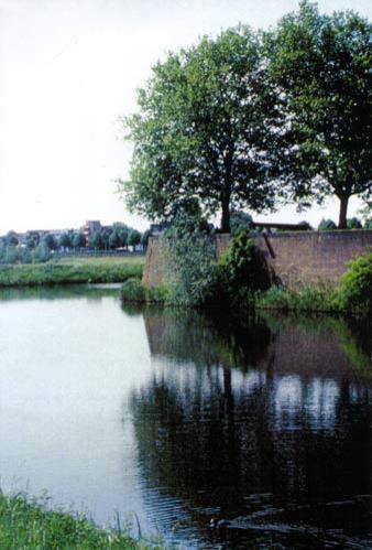
The city of 's-Hertogenbosch is the capital city of North Brabant, one of the twelve provinces in the Netherlands. The city has approximately 130,000 inhabitants, provides jobs for approximately 93,000 people and a further 250,000-500,000 people who live in the surrounding areas. It is one of the most economically vibrant cities in the Netherlands. The first period during which the city flourished was the period from 1200-1600. During this time 's-Hertogenbosch developed into a fortified city which retained its military importance until late in the 19th century. It was for this reason that the city was, for a long time, restricted in size to the area inside the fortified city. Even today, most aspects of the city's cultural and economic life take place in the city centre, which dates back to medieval times, within the boundaries of the fortified city which are still plain to see.
Context. The importance of the plan for the city
The area around the city's fortifications constitute a unique addition to what is already a unique city centre, with the distinctive cathedral of St Jan, the nightlife area around the Parade square and the Binnendieze [ river which flows partially under the city]. A still somewhat 'dormant' feature is the fortifications which are largely still intact but rather concealed. The fortifications need to be restored to their former glory and we need to treat their medieval character and ambience with more intensity and awareness. The fortifications constitute a special feature of our public space in that theyare a very important link with the natural environment. The fortifications development project is large-scale, imaginative, unique and innovative and forms the basis for a sustainable, physical, economic and social impulse which will result in a lively city centre forming an important link with modernisation in adjacent neighbourhoods and districts.
The most important objective of the fortifications development plan is to reinforce the form and meaning of the fortifications based on an integral approach and by bringing about a process of revitalisation, modernisation and preservation. This general aim is the interrelationship of the following project objectives:
• the preservation of our historic inheritance
• the reinforcement of the cultural-historical value
• the improvement of the quality of the public space
• the reinforcement of the natural and ecological values
• a maximum correlation (link) with other relevant urban developments
• the reinforcement of the tourist infrastructure
• space for innovative architecture
• business developments and employment opportunities
The ambition of the fortifications project is that it should add something to the city of the future in all the areas referred to, with history being used not as a barrier but rather a source of inspiration for innovative solutions, while interests which may seem to be conflicting are reconciled .
Cultural heritage
The fortifications development plan resulted originally from the necessity to restore the fortification walls which were in a poor state of repair. During the course of the process it transpired that the result would gain considerably in quality if the project were to be linked with other policy areas. Those involved started looking for win-win situations. Doing justice to historical values and respect for the city's legacy remained the points of departure. This forced designers to devise a variety of innovative solutions. The way in which they succeeded in doing so is an example for other projects. The project shows that the concepts of redevelopment and the preservation of cultural- historical values can very easily co-exist.
This is also demonstrated by the following elements:
Integration of historical elements and modern functions.
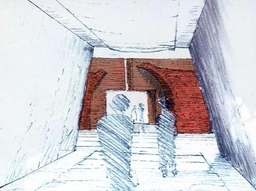
Based on the idea that historical elements ought to be a source of inspiration for the future, new functions have been integrated into the fortifications plan in relation to a number of locations. For example, the restoration and even the reconstruction of part of the fortification wall with corresponding bastions have been integrated with a car park, with the walls once again being positioned in the water and with the fortified moat being partly restored. The reconstruction of the ground level, which was lower in medieval times, means that pedestrians leaving the car park cross the path of traffic at a different level. A further example is a new tunnel under the ramparts which is intended to link the river (the Binnendieze), which for the most part flows under the city centre, with the fortified moat. This has made it possible for tourists to be taken on excursions along the fortified moat. This tunnel also means that the underground excavations become visible, while it is also intended to improve the drainage of the Binnendieze.
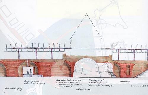
Highlighting aspects of history using modern resources
The aim is to find architectural and urban development resources which are modern and which provide solutions to the problems of today but which also make it easier for us to experience the city's history. Examples are the new style city gates. Whereas, in the past, the city gates fell victim to traffic, new constructions are being erected in the form of modern gate structures and/or abutments which function as accommodation for residences or offices. From the point of view of urban design, a better transition is achieved between the area outside the fortified city and the city centre which has restricted car access. It goes without saying that these sorts of proposals demand innovative architecture.
The use of know-how of history of the building construction and archaeology in the drawing off the plan
Before the plan was drawn up, preliminary investigations were carried out into the history of the building construction and archaeological aspects. Wherever hidden historical elements which might affect the plan were expected, additional research was carried out with the results being integrated into the plan. An attempt was also made to arrange the implementation with such flexibility that plans could also be adapted to new findings made during the course of the construction work. In that sense, the project is anticipating the challenges facing architects and urban developers as a result of the ratification of the treaty of Valetta.
Integrated method of approach; searching for win-win situations
An integrated approach to the project was opted for with as many parties being involved as possible. This is resulting in exceptional solutions being found. For example, the new Fortifications Information Centre will also serve as a base from which people can explore the Bossche Broek nature reserve. On the other side of the fortified city, cooperation is taking place with the Kruithuis museum. Here an integrated plan is being developed for new building work to the museum and the restoration of, and provision of access to, the fortification wall.
New restoration techniques
The restoration of fortification walls in an environment which is subject to such intensive use requires new technical solutions, for example in cases in which walls cannot be reached from one side due to the intensity of traffic or if restoration is required while, at the same time, rare plants and animals have to be preserved on the walls. The same applies to trees which may be interfering with the walls but which, at the same time, are essential environmental features.
Integration of city and nature
The adjacent nature reserve and the forelands near the fortification walls are important ecological connecting zones. Despite the urban location, these are very valuable oases of tranquillity for plant and animal life. For example, there are bat colonies behind and under the walls. The plan aims to find innovative solutions to preserve and improve such situations.
Programme
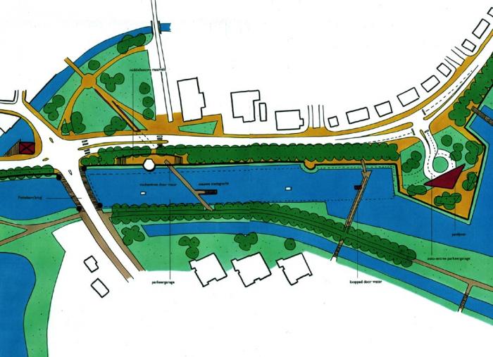
There are nine sub-projects and the numbers in brackets refer to the figure Overview of Fortified Den Bosch.
1. Bastion Oranje - Hekelsluis (map numbers 10,11,14,15,18-20
- restoration of wall, roundel, bastion
- redevelopment of the Zuidwal and Bastion Oranje
- realisation of tourist information point De Kanonkelder with views over the Bossche Broek
- creation of a pick-up point at the Singelgracht.
2. Bastion Vught - Parklaan (map numbers 7,8,12,13,14, 20)
- restoration of Spinhuiswal walls (and redevelopment plan)
- restoration of Parklaan walls (and redevelopment plan)
- creation of new passageway of Kruisbroedershekel under the fortified city and roadway
- increase in number of boat trip routes.
3. Bastion Vught bridge link with Bossche Broek (map number 4)
- pedestrian route over Bossche Broek quayside along the Singelgracht, with a bridge over the Dommel river and Vughterstuw. Later modern gate buildings are to be built on this bastion.
4. Sint Janssingel - Westwal (map numbers 70-78)
- history of building investigation and redevelopment plan for the banks of the Dommel river near the Westwal and Sint Janssingel; restoration and modernisation of the walls with occasional additions
- transfer of car parking facilities in order to allow the creation of a walkway along the perimeter of the fortified city
- redevelopment of the slopes to improve views of the fortification walls.
5. Citadel - Harbour (map numbers 58,64 and 67)
- restoration of historic swing bridge
- pedestrian link with city centre
- restoration of Sortiebrug to improve access to the citadel
- redesign of the water gate to include a restaurant/cafe
- the citadel's 'fifth point' is to be restored and modernised at a later date.
6. Kasterenwal - Noordwal (map numbers 53-57)
- integration with De Kruithuis new museum building
- redevelopment plan for the Kasterenwal and Noordwal area. Revival of wall by means of modern additions.
7. Hinthamerpoort - Muntelbolwerk (map numbers 45-52)
- the Bartenbrug, the vicinity of the water tower, the quays and the pedestrian bridge near the Aa river are to be made more prominent. Improvement of Bastion
- realisation of new roundel
- the ramparts in the Muntelbolwerk public space to be made recognisable again
8. Bastion Baselaar - Bastion St. Antonie (map numbers 35 - 39)
- redevelopment of whole area; the entrance to the fortified city to be made more prominent by a 'land bridge', relocation of tennis complex.
9. Pettelaarseweg - Bastion Baselaar (25- 34)
- realisation of underground car park on the Vonk and Vlamterrein coupled with making the fortification walls more visible
- historic restoration of the tower in front of the Judasbrug
- reconstruction of medieval ground level with a pedestrian link from car park via city wall to the city centre.

Related articles:
- Cultural Heritage: Apeldoorn (The Netherlands)
- Cultural Heritage: Faenza (Italy)
- Cultural Heritage: Genoa (Italy)
- Cultural Heritage: Goerlitz (Germany)
- Cultural Heritage: Lucca (Italy)
- Cultural Heritage: Metz (France)
- Cutural Heritage: Nancy (France)
- Cultural heritage: Valladolid (Spain)
- Cultural Heritage: Vienna (Austria)
- Cultural Heritage: Zaragoza (Spain)


Planum
The Journal of Urbanism
ISSN 1723-0993
owned by
Istituto Nazionale di Urbanistica
published by
Planum Association